Ready to explore the amazing North Carolina coast? This interactive resource guide will help you discover over 300 miles of beaches, charming towns, and stunning nature, from the wild Outer Banks to the tranquil Cape Fear shores. Whether you’re planning a family beach trip, searching for epic surf breaks, or craving a quiet getaway, our guide—complete with interactive maps—will help you find the perfect beach, nearby attractions, and even live weather updates. Let’s dive in!
Discovering the Tar Heel Shore
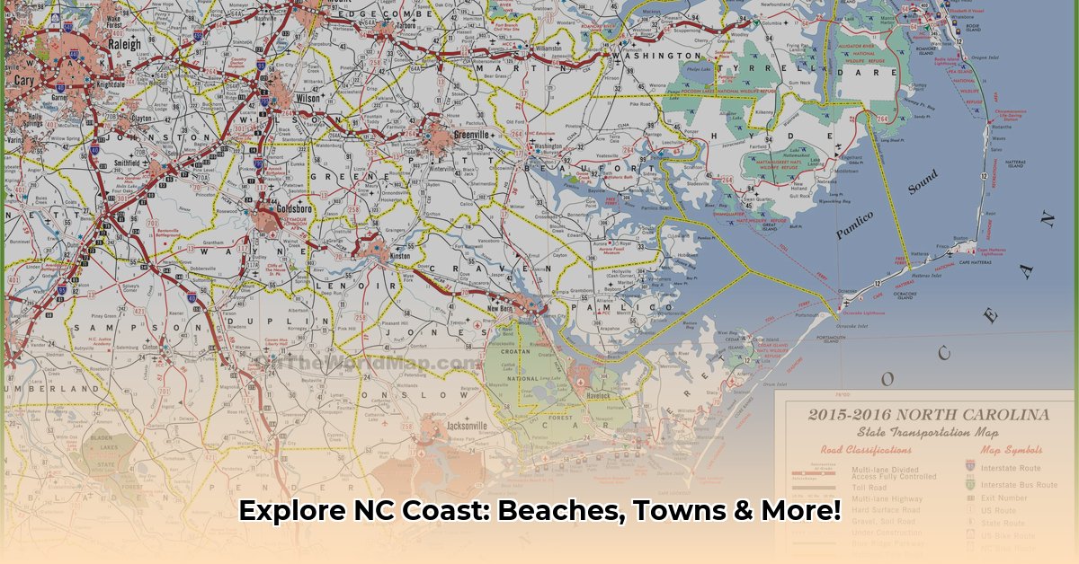
Interactive Maps: Your Coastal Compass
Interactive maps transform how we experience a place. Zoom in on secluded coves, scope out surf spots, or locate that acclaimed seaside restaurant. These digital tools offer granular detail, allowing you to virtually explore every nook and cranny, discover hidden gems, and plan your perfect coastal escape.
Coastal Regions: A Diverse Tapestry
The North Carolina coastline is a mosaic of distinct regions, each with its own unique character. From the wild horses and windswept dunes of the Outer Banks to the tranquil beaches of the Crystal Coast, and the historic charm of the Cape Fear region to the laid-back Brunswick Islands, a good map reveals the subtle nuances of each, helping you choose the perfect destination.
Beyond the Beaches: Coastal Gems
While the beaches are the main attraction, the North Carolina coast offers much more. Charming towns, historic lighthouses, vibrant estuaries, and quaint fishing villages dot the landscape. Use a map to uncover these hidden gems, find parks and nature preserves, and locate nearby amenities.
| Beach | Region | Known For | May Appeal To… |
|---|---|---|---|
| Cape Hatteras | Outer Banks | Dramatic shoreline, iconic lighthouse | Adventurers, history buffs, nature lovers |
| Wrightsville | Cape Fear | Surfing, lively beach town atmosphere | Surfers, social butterflies, foodies |
| Emerald Isle | Crystal Coast | Family-friendly, calm waters | Families, those seeking relaxation |
| Ocracoke | Outer Banks | Remote beauty, ferry access | Those seeking solitude, off-the-beaten-path experiences |
Planning Your Escape: Tips & Resources
A map of the North Carolina coastline is your trip-planning companion. Consider the season—summer sun or fall foliage? Think about transportation—scenic drive, ferry, or chartered boat? Explore accommodation options—cozy cottages or luxurious resorts? Real-time resources like live webcam feeds and weather forecasts are essential for staying informed, safe, and maximizing your enjoyment.
The Ever-Changing Coastline
Our coastlines are constantly reshaped by the interaction of land and sea. Erosion, currents, and storms sculpt the shoreline, and researchers suggest these forces are intensifying due to rising sea levels. Ongoing research is crucial for protecting these ecosystems, and understanding their evolution. Future interactive maps may incorporate real-time data about coastal changes.
Finding Your Perfect Beach
North Carolina offers a diverse coastline, from the wild Outer Banks to the calmer Crystal Coast and historic Cape Fear. An interactive map is your digital treasure map, helping you pinpoint your ideal spot based on amenities, accessibility, and parking. Consider the vibe you’re seeking—wild and free, calm and serene, or historic and intriguing—to choose the right region. Think about your ideal beach day—bustling or secluded? Consider practicalities like restrooms, showers, lifeguards, and parking. Explore beyond the beach—charming towns, historic lighthouses, maritime forests, and scenic trails enhance the coastal experience. Plan your transportation, accommodation, dining, and activities to create a personalized beach getaway.
Interactive Map Features
Interactive maps enhance exploration by providing dynamic tools.
Navigation Tools
- Zooming and Panning: Zoom in for details like beach access points and marina layouts, or pan across the map like a coastal drive.
- Layers: Toggle between different views showing wave heights, public beach access locations, or erosion-prone areas.
- Search & Discover: Locate specific beaches, marinas, or other points of interest with the search bar.
Planning with Interactive Maps
Use these features to research beaches, check parking, view webcam feeds, find kayaking spots, and locate nearby restaurants. While a truly comprehensive, up-to-date interactive map of the entire NC coast is still developing, ongoing advancements in data visualization and user interface design are bringing us closer.
Regional Breakdown
Outer Banks: Where Wild Horses Roam
The Outer Banks, a chain of barrier islands, offer wild horses, windswept dunes, and historic lighthouses. From surfing to exploring shipwrecks, this region combines nature and history. Ongoing research continues to uncover the secrets of this dynamic area.
Crystal Coast: Family Fun & Clear Waters
South of the Outer Banks, the Crystal Coast boasts 85 miles of calm, clear waters ideal for families. Quaint towns, shelling opportunities, and diverse marine ecosystems await.
Cape Fear: History Meets Nature
Where the Cape Fear River meets the Atlantic, the historic port city of Wilmington offers vibrant arts, architecture, and a bustling riverfront. Beyond the city, quiet beaches, marshes, and the Cape Fear River create a unique blend of natural and built environments.
Regional Deep Dive
| Region | Characteristics | Key Attractions | Possible Activities |
|---|---|---|---|
| Outer Banks | Wild horses, historic lighthouses, windswept dunes | Cape Hatteras National Seashore, Wright Brothers National Memorial | Surfing, windsurfing, kiteboarding, fishing, exploring historic sites |
| Crystal Coast | Calm, clear waters, family-friendly, charming towns | Fort Macon State Park, North Carolina Aquarium at Pine Knoll Shores | Swimming, snorkeling, paddleboarding, kayaking, shelling, visiting local markets |
| Cape Fear | Historic port city, beaches, marshes, riverfront | Wilmington Riverwalk, Battleship North Carolina, Fort Fisher State Recreation Area | Exploring historic Wilmington, boating, fishing, birdwatching, hiking nature trails |
An interactive map is invaluable for exploring each region, planning your beach day, and discovering hidden gems. While maps and guides are helpful, the best way to experience the North Carolina coast is to visit and explore firsthand.
- 10 Facts About Hydropowers Global Impact and Future Potential - January 17, 2026
- Interesting Facts About Hydroelectric Energy and Its Global Impact - January 16, 2026
- Interesting Facts About Hydro Energys Power and Future - January 15, 2026
