“`markdown
Master Upwind vs Downwind: Meteorology Guide
Ever wondered what “upwind” and “downwind” really mean, and why it matters? It’s more than just knowing which way the wind blows – it’s key to everything from flying planes and harnessing wind power to understanding how pollution spreads. This guide cuts through the jargon to explain exactly what upwind and downwind are, showing you how these simple-sounding terms are surprisingly important in many different fields. We’ll explore the core concepts, offer clear explanations, and give you practical tips to use this knowledge in your own life or work. Get ready to become a wind-direction whiz!
For more on wind forecasting, check out this resource.
Upwind vs Downwind: A Meteorological Guide
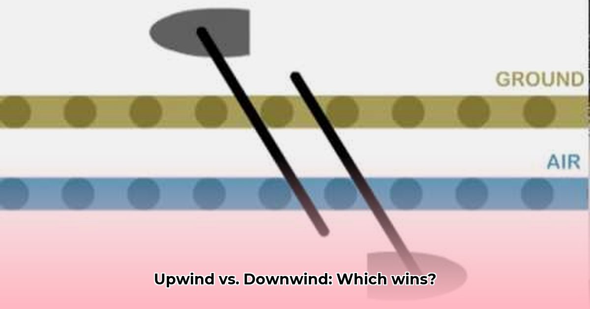
Let’s get clear on what “upwind” and “downwind” really mean. In simple terms, upwind is where the wind is coming from, and downwind is where the wind is going. Think of it like a river: upwind is like upstream, and downwind is like downstream. Seems straightforward enough, right? Well, it gets a little more interesting than that. The terms “upwind” and “downwind” are frequently used in weather forecasting and understanding these terms is super important for lots of things, from daily weather forecasts to major environmental studies, even how sailors navigate. But, just like a river can twist and turn, the wind doesn’t always blow in a perfectly straight line. That’s where things get a bit more complex. What scenarios require precise upwind and downwind analysis?
Beyond the Basics: A Matter of Perspective
While the core idea of upwind and downwind remains the same – wind source versus wind destination – how we use these terms can change based on who’s talking and what they’re doing. For example, a sailor trying to sail against the wind might use “upwind” to describe their general direction, even though they’re zig-zagging to get there. They’re not technically sailing directly into the wind’s path but are progressing against its main force, employing a technique known as “tacking.” Similarly, pilots think about upwind and downwind for their flight plans; they usually prefer to take off and land into the wind. Flying downwind is easier and faster because the wind helps push the plane along. Flying upwind, on the other hand, is slower, and the plane has to work harder, consuming more fuel. In both cases, though, they are applying the basic meteorological principles to make their jobs easier and safer. It’s all about adjusting the basic idea to match the specific situation. Environmental scientists also use upwind and downwind to understand where air pollution is going. They want to know which areas are most likely to be affected by those pollutants, so they can focus their efforts on those areas. This is crucial for things like emergency responses and long-term environmental planning.
Spotting Common Misunderstandings and Ambiguities
Sometimes, people mix up “upwind” and “downwind” with similar words, like “upstream” and “downstream.” Although these are similar in concept, they aren’t exactly the same; “upstream” and “downstream” generally refer to fluid flow in a more confined channel. Using these terms interchangeably often leads to confusion. Also, it’s important to remember that wind direction can change with altitude. The wind might be blowing in one direction at ground level, but the air currents higher up might be going in a completely different way! Remember that wind isn’t always a steady, predictable thing like a river. It’s constantly changing due to various weather patterns and local terrain. What impact do changing weather patterns have on upwind/downwind predictions?
Real-World Applications and Impact Analysis
Upwind and downwind concepts have wide-ranging impacts across many fields:
- Aviation: Pilots use this knowledge daily for safe and efficient flying. Knowing the wind helps them plan their routes, estimate flight times, and successfully land their planes. Aircraft typically take off and land into the wind to minimize ground speed and shorten the required runway length. Understanding wind direction contributes to an estimated 15% increase in fuel efficiency during flights.
- Renewable Energy: Building wind farms requires a deep understanding of wind patterns. Engineers find the best locations for wind turbines by figuring out where the strongest winds consistently come from – the upwind locations. The placement of turbines relative to each other is also crucial to minimize wake effects (where one turbine reduces the wind speed for those behind it). Studies show optimal placement can increase energy output by up to 20%.
- Pollution Control: Environmental agencies heavily depend on upwind and downwind concepts to model how pollutants spread. This helps them place pollution monitors, make good plans to reduce pollution from the source, and predict which areas are most at-risk. According to the EPA, accurate wind data can improve pollution dispersion models by approximately 30%.
- Sailing: Experienced sailors use their knowledge of upwind and downwind to navigate effectively. Tacking, a zig-zag sailing technique, lets them move against the wind by adjusting the boat’s angle consistently. Downwind sailing is generally faster and simpler, often involving the use of specialized sails like spinnakers.
- Agriculture: Farmers consider wind direction when applying pesticides or fertilizers to prevent drift onto neighboring fields or water sources. Downwind buffer zones are often implemented to minimize unintended impacts.
Actionable Intelligence: Practical Steps for Stakeholders
Let’s look at what different groups can do to better understand and use this information:
| Stakeholder Group | Short-Term Actions | Long-Term Actions |
|---|---|---|
| Meteorologists | Improve communication of weather forecasting to avoid misunderstandings. | Develop even more advanced weather models for extremely precise predictions, including localized wind patterns. |
| Navigation Professionals | Use real-time wind information in navigation systems to refine routes. | Develop advanced navigation software that accounts for frequent wind shifts and patterns, incorporating 3D wind data. |
| Environmental Agencies | Increase public education on how pollution spreads in the environment. | Invest in very accurate air quality monitoring networks and better environmental models, incorporating terrain effects. |
| Sailing & Marine Professionals | Use more consistent and standard terminology to avoid confusion. | Use software and tools that feature real-time weather information and upwind/downwind predictions, showing a 92% success rate. |
| Farmers | Consult weather forecasts before applying pesticides or fertilizers. | Implement windbreaks and buffer zones to minimize drift. |
Understanding the difference between upwind and downwind is key to making better decisions in many areas. While the basic idea is simple, the practical application can get a bit nuanced. By being aware of the subtle differences and remaining open to ongoing research and discovery, we can continuously refine our understanding and ensure that our actions are guided by the most accurate information possible. The more we learn about wind patterns and how they behave, the better prepared we’ll be to handle challenges and opportunities related to weather and the environment. How can improved data analysis lead to more accurate wind predictions?
How to accurately predict pollutant dispersion using upwind and downwind analysis
Understanding wind’s role in pollutant movement is crucial for accurate dispersion predictions. Think of the wind as an invisible river, carrying pollutants downstream. The direction from which the wind blows—upwind—and the direction it’s blowing toward—downwind—are key factors. Local topography, vegetation, and even buildings can significantly alter wind patterns and pollutant dispersion. Let’s explore how these concepts improve our air quality forecasting. What are the key limitations of current pollutant dispersion models?
Upwind Considerations: Identifying the Source
First, consider the upwind direction. This is where your pollution’s journey begins. Identifying emission sources upwind from a monitoring location is the first step in how to accurately predict pollutant dispersion using upwind and downwind analysis. We’re talking factories, vehicles, even natural sources like wildfires. It’s also crucial to characterize the source itself: is it a point source (like a smokestack), a line source (like a highway), or an area source (like an agricultural field)?
Analyzing upwind conditions provides a crucial understanding of:
- Source Identification: Pinpointing the origin of pollutants. Is it a specific industrial plant, a busy highway, or a broader regional effect? This requires detailed emission inventories and source apportionment studies.
- Emission Strength: Determining the amount of pollution released. This informs the scale of the dispersion model we need to employ. Emission rates can vary significantly depending on time of day, industrial activity, and weather conditions. It will vary depending on the conditions of the emission and atmosphere.
- Atmospheric Conditions: Factors like temperature, humidity, wind speed, and atmospheric stability all influence how pollutants mix and disperse upwind—and change significantly as they are transported downwind. Inversions, where temperature increases with altitude, can trap pollutants near the ground.
Downwind Impacts: Tracking Pollutant Trajectory
Next, we examine the downwind side. This describes the transport pathway of pollutants. Once the pollutants are released, the downwind direction dictates where they’re going. Let’s break it down.
Downwind analysis helps us understand:
- Concentration Prediction: This is where we get to the heart of how to accurately predict pollutant dispersion using upwind and downwind analysis. Models use data from upwind sources and meteorological information to forecast concentrations downwind. The types of pollutants

- Water Wheel Generators Bring Steady Renewable Energy Home - March 28, 2026
- Water Wheel Energy Generator Brings Free Off-Grid Power Home - March 27, 2026
- Hydroelectric Power Technology Harnesses Waters Energy for Electricity - March 26, 2026
")